|
|
|||||||||||||||||
| Point ID: 798 | Downloads | Plots | Site Data | Code: 07JF003 |
|
|
|||||||||||||||||
| Download | |
|---|---|
| Site Descriptor Information | Site Time Series Data |
| Link to all available data | |
| View: | Time Series | All |
| Units: | mm |
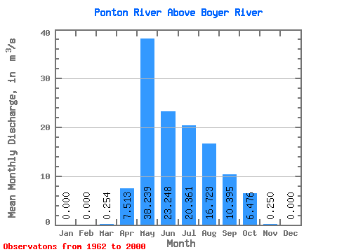
| Statistic | Jan | Feb | Mar | Apr | May | Jun | Jul | Aug | Sep | Oct | Nov | Dec | Annual |
|---|---|---|---|---|---|---|---|---|---|---|---|---|---|
| Mean | 0.00 | 0.00 | 0.25 | 7.51 | 38.24 | 23.25 | 20.36 | 16.72 | 10.39 | 6.48 | 0.25 | 0.00 | |
| Standard Deviation | 0.34 | 6.63 | 15.73 | 13.04 | 13.38 | 13.52 | 8.11 | 5.15 | |||||
| Min | 0.00 | 0.00 | 0.00 | 0.07 | 2.09 | 1.96 | 2.54 | 1.29 | 0.88 | 0.43 | 0.25 | 0.00 | |
| Max | 0.00 | 0.00 | 1.14 | 24.20 | 70.40 | 65.90 | 58.30 | 48.10 | 31.00 | 20.40 | 0.25 | 0.00 | |
| Coefficient of Variation | 1.34 | 0.88 | 0.41 | 0.56 | 0.66 | 0.81 | 0.78 | 0.80 |
 Return to R-Arctic Net Home Page