|
|
|||||||||||||||||
| Point ID: 798 | Downloads | Plots | Site Data | Code: 07JF003 |
|
|
|||||||||||||||||
| Download | |
|---|---|
| Site Descriptor Information | Site Time Series Data |
| Link to all available data | |
| View: | Time Series | All |
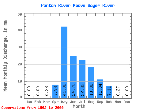
| Units: | m3/s |
| Statistic | Jan | Feb | Mar | Apr | May | Jun | Jul | Aug | Sep | Oct | Nov | Dec | Annual |
|---|---|---|---|---|---|---|---|---|---|---|---|---|---|
| Mean | 0.00 | 0.00 | 0.28 | 7.98 | 41.97 | 24.70 | 22.35 | 18.35 | 11.04 | 7.11 | 0.27 | 0.00 | |
| Standard Deviation | 0.37 | 7.04 | 17.27 | 13.85 | 14.68 | 14.84 | 8.61 | 5.65 | |||||
| Min | 0.00 | 0.00 | 0.00 | 0.07 | 2.29 | 2.08 | 2.79 | 1.42 | 0.94 | 0.47 | 0.27 | 0.00 | |
| Max | 0.00 | 0.00 | 1.25 | 25.71 | 77.27 | 70.00 | 63.99 | 52.79 | 32.93 | 22.39 | 0.27 | 0.00 | |
| Coefficient of Variation | 1.34 | 0.88 | 0.41 | 0.56 | 0.66 | 0.81 | 0.78 | 0.80 |
 Return to R-Arctic Net Home Page