|
|
|||||||||||||||||
| Point ID: 7931 | Downloads | Plots | Site Data | Code: 3527 |
|
|
|||||||||||||||||
| Download | |
|---|---|
| Site Descriptor Information | Site Time Series Data |
| Link to all available data | |
| View: | Time Series | All |
| Units: | mm |
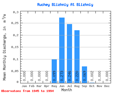
| Statistic | Jan | Feb | Mar | Apr | May | Jun | Jul | Aug | Sep | Oct | Nov | Dec | Annual |
|---|---|---|---|---|---|---|---|---|---|---|---|---|---|
| Mean | 0.00 | 0.00 | 0.00 | 0.00 | 0.10 | 0.27 | 0.25 | 0.22 | 0.07 | 0.00 | 0.00 | 0.00 | 0.07 |
| Standard Deviation | 0.00 | 0.00 | 0.00 | 0.00 | 0.14 | 0.22 | 0.24 | 0.13 | 0.08 | 0.01 | 0.00 | 0.00 | 0.03 |
| Min | 0.00 | 0.00 | 0.00 | 0.00 | 0.00 | 0.01 | 0.04 | 0.01 | 0.00 | 0.00 | 0.00 | 0.00 | 0.03 |
| Max | 0.00 | 0.00 | 0.00 | 0.00 | 0.79 | 0.87 | 1.17 | 0.57 | 0.34 | 0.03 | 0.00 | 0.00 | 0.15 |
| Coefficient of Variation | 1.45 | 0.80 | 0.99 | 0.61 | 1.10 | 2.74 | 0.45 |
 Return to R-Arctic Net Home Page