|
|
|||||||||||||||||
| Point ID: 7931 | Downloads | Plots | Site Data | Code: 3527 |
|
|
|||||||||||||||||
| Download | |
|---|---|
| Site Descriptor Information | Site Time Series Data |
| Link to all available data | |
| View: | Time Series | All |
| Units: | m3/s |
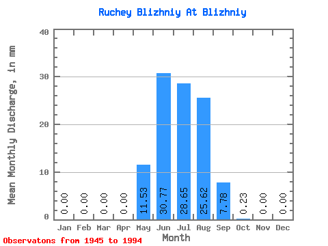
| Statistic | Jan | Feb | Mar | Apr | May | Jun | Jul | Aug | Sep | Oct | Nov | Dec | Annual |
|---|---|---|---|---|---|---|---|---|---|---|---|---|---|
| Mean | 0.00 | 0.00 | 0.00 | 0.00 | 11.49 | 30.73 | 28.59 | 25.59 | 7.83 | 0.23 | 0.00 | 0.00 | 99.13 |
| Standard Deviation | 0.00 | 0.00 | 0.00 | 0.00 | 16.68 | 24.56 | 28.18 | 15.54 | 8.63 | 0.63 | 0.00 | 0.00 | 44.11 |
| Min | 0.00 | 0.00 | 0.00 | 0.00 | 0.35 | 0.68 | 4.19 | 1.28 | 0.00 | 0.00 | 0.00 | 0.00 | 44.60 |
| Max | 0.00 | 0.00 | 0.00 | 0.00 | 91.98 | 98.05 | 136.23 | 66.37 | 38.32 | 3.96 | 0.00 | 0.00 | 206.97 |
| Coefficient of Variation | 1.45 | 0.80 | 0.99 | 0.61 | 1.10 | 2.74 | 0.45 |
 Return to R-Arctic Net Home Page