|
|
|||||||||||||||||
| Point ID: 7926 | Downloads | Plots | Site Data | Code: 3512 |
|
|
|||||||||||||||||
| Download | |
|---|---|
| Site Descriptor Information | Site Time Series Data |
| Link to all available data | |
| View: | Time Series | All |
| Units: | mm |
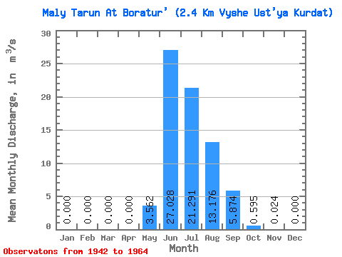
| Statistic | Jan | Feb | Mar | Apr | May | Jun | Jul | Aug | Sep | Oct | Nov | Dec | Annual |
|---|---|---|---|---|---|---|---|---|---|---|---|---|---|
| Mean | 0.00 | 0.00 | 0.00 | 0.00 | 3.56 | 27.03 | 21.29 | 13.18 | 5.87 | 0.59 | 0.02 | 0.00 | 5.92 |
| Standard Deviation | 0.00 | 0.00 | 0.00 | 0.00 | 3.27 | 12.72 | 11.38 | 5.28 | 5.04 | 0.33 | 0.04 | 0.00 | 1.55 |
| Min | 0.00 | 0.00 | 0.00 | 0.00 | 0.05 | 6.45 | 6.04 | 3.68 | 1.87 | 0.16 | 0.00 | 0.00 | 3.71 |
| Max | 0.00 | 0.00 | 0.00 | 0.00 | 10.60 | 45.20 | 46.30 | 24.10 | 22.60 | 1.37 | 0.15 | 0.00 | 9.17 |
| Coefficient of Variation | 0.92 | 0.47 | 0.54 | 0.40 | 0.86 | 0.56 | 1.71 | 0.26 |
 Return to R-Arctic Net Home Page