|
|
|||||||||||||||||
| Point ID: 7926 | Downloads | Plots | Site Data | Code: 3512 |
|
|
|||||||||||||||||
| Download | |
|---|---|
| Site Descriptor Information | Site Time Series Data |
| Link to all available data | |
| View: | Time Series | All |
| Units: | m3/s |
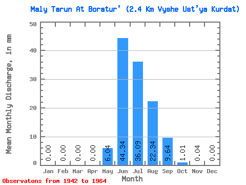
| Statistic | Jan | Feb | Mar | Apr | May | Jun | Jul | Aug | Sep | Oct | Nov | Dec | Annual |
|---|---|---|---|---|---|---|---|---|---|---|---|---|---|
| Mean | 0.00 | 0.00 | 0.00 | 0.00 | 6.04 | 44.34 | 36.09 | 22.33 | 9.64 | 1.01 | 0.04 | 0.00 | 118.32 |
| Standard Deviation | 0.00 | 0.00 | 0.00 | 0.00 | 5.54 | 20.87 | 19.29 | 8.96 | 8.27 | 0.57 | 0.07 | 0.00 | 30.97 |
| Min | 0.00 | 0.00 | 0.00 | 0.00 | 0.08 | 10.58 | 10.24 | 6.24 | 3.07 | 0.27 | 0.00 | 0.00 | 74.01 |
| Max | 0.00 | 0.00 | 0.00 | 0.00 | 17.97 | 74.15 | 78.48 | 40.85 | 37.08 | 2.32 | 0.25 | 0.00 | 183.25 |
| Coefficient of Variation | 0.92 | 0.47 | 0.54 | 0.40 | 0.86 | 0.56 | 1.71 | 0.26 |
 Return to R-Arctic Net Home Page