|
|
|||||||||||||||||
| Point ID: 792 | Downloads | Plots | Site Data | Code: 07JC002 |
|
|
|||||||||||||||||
| Download | |
|---|---|
| Site Descriptor Information | Site Time Series Data |
| Link to all available data | |
| View: | Time Series | All |
| Units: | mm |
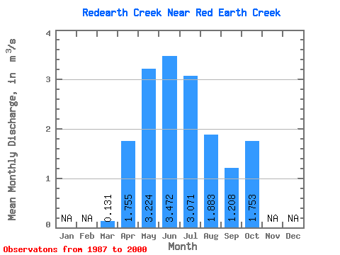
| Statistic | Jan | Feb | Mar | Apr | May | Jun | Jul | Aug | Sep | Oct | Nov | Dec | Annual |
|---|---|---|---|---|---|---|---|---|---|---|---|---|---|
| Mean | 0.13 | 1.75 | 3.22 | 3.47 | 3.07 | 1.88 | 1.21 | 1.75 | |||||
| Standard Deviation | 0.17 | 1.93 | 3.37 | 2.99 | 3.31 | 2.44 | 1.51 | 3.50 | |||||
| Min | 0.03 | 0.13 | 0.30 | 0.04 | 0.05 | 0.01 | 0.04 | 0.04 | |||||
| Max | 0.69 | 6.79 | 12.50 | 9.45 | 11.20 | 8.78 | 4.73 | 13.30 | |||||
| Coefficient of Variation | 1.29 | 1.10 | 1.05 | 0.86 | 1.08 | 1.30 | 1.25 | 2.00 |
 Return to R-Arctic Net Home Page