|
|
|||||||||||||||||
| Point ID: 792 | Downloads | Plots | Site Data | Code: 07JC002 |
|
|
|||||||||||||||||
| Download | |
|---|---|
| Site Descriptor Information | Site Time Series Data |
| Link to all available data | |
| View: | Time Series | All |
| Units: | m3/s |
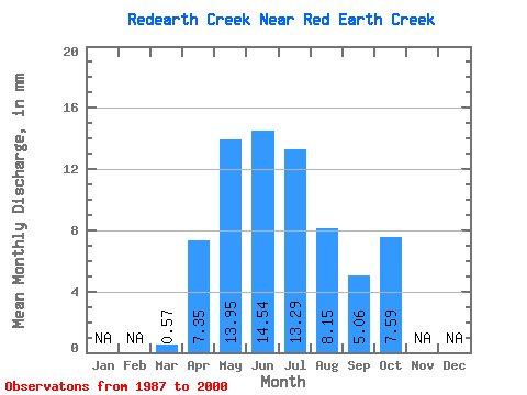
| Statistic | Jan | Feb | Mar | Apr | May | Jun | Jul | Aug | Sep | Oct | Nov | Dec | Annual |
|---|---|---|---|---|---|---|---|---|---|---|---|---|---|
| Mean | 0.57 | 7.35 | 13.95 | 14.54 | 13.29 | 8.15 | 5.06 | 7.58 | |||||
| Standard Deviation | 0.73 | 8.08 | 14.59 | 12.51 | 14.32 | 10.57 | 6.31 | 15.13 | |||||
| Min | 0.14 | 0.54 | 1.29 | 0.17 | 0.22 | 0.06 | 0.17 | 0.19 | |||||
| Max | 3.00 | 28.43 | 54.08 | 39.57 | 48.45 | 37.98 | 19.81 | 57.54 | |||||
| Coefficient of Variation | 1.29 | 1.10 | 1.05 | 0.86 | 1.08 | 1.30 | 1.25 | 2.00 |
 Return to R-Arctic Net Home Page