|
|
|||||||||||||||||
| Point ID: 7916 | Downloads | Plots | Site Data | Code: 3467 |
|
|
|||||||||||||||||
| Download | |
|---|---|
| Site Descriptor Information | Site Time Series Data |
| Link to all available data | |
| View: | Time Series | All |
| Units: | mm |
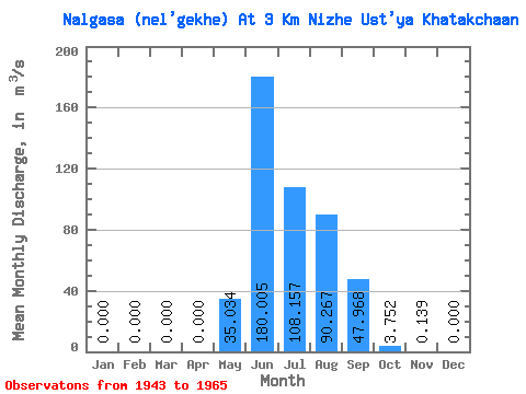
| Statistic | Jan | Feb | Mar | Apr | May | Jun | Jul | Aug | Sep | Oct | Nov | Dec | Annual |
|---|---|---|---|---|---|---|---|---|---|---|---|---|---|
| Mean | 0.00 | 0.00 | 0.00 | 0.00 | 35.03 | 180.00 | 108.16 | 90.27 | 47.97 | 3.75 | 0.14 | 0.00 | 38.78 |
| Standard Deviation | 0.00 | 0.00 | 0.00 | 0.00 | 21.50 | 88.45 | 68.45 | 64.11 | 48.66 | 2.42 | 0.18 | 0.00 | 13.46 |
| Min | 0.00 | 0.00 | 0.00 | 0.00 | 3.25 | 62.60 | 36.00 | 14.20 | 9.62 | 1.52 | 0.00 | 0.00 | 17.39 |
| Max | 0.00 | 0.00 | 0.00 | 0.00 | 77.40 | 370.00 | 298.00 | 275.00 | 204.00 | 11.90 | 0.70 | 0.00 | 62.30 |
| Coefficient of Variation | 0.61 | 0.49 | 0.63 | 0.71 | 1.01 | 0.65 | 1.32 | 4.58 | 0.35 |
 Return to R-Arctic Net Home Page