|
|
|||||||||||||||||
| Point ID: 7916 | Downloads | Plots | Site Data | Code: 3467 |
|
|
|||||||||||||||||
| Download | |
|---|---|
| Site Descriptor Information | Site Time Series Data |
| Link to all available data | |
| View: | Time Series | All |
| Units: | m3/s |
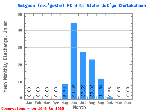
| Statistic | Jan | Feb | Mar | Apr | May | Jun | Jul | Aug | Sep | Oct | Nov | Dec | Annual |
|---|---|---|---|---|---|---|---|---|---|---|---|---|---|
| Mean | 0.00 | 0.00 | 0.00 | 0.00 | 8.94 | 44.44 | 27.59 | 23.02 | 11.84 | 0.96 | 0.03 | 0.00 | 116.55 |
| Standard Deviation | 0.00 | 0.00 | 0.00 | 0.00 | 5.48 | 21.84 | 17.46 | 16.35 | 12.01 | 0.62 | 0.04 | 0.00 | 40.45 |
| Min | 0.00 | 0.00 | 0.00 | 0.00 | 0.83 | 15.45 | 9.18 | 3.62 | 2.38 | 0.39 | 0.00 | 0.00 | 52.27 |
| Max | 0.00 | 0.00 | 0.00 | 0.00 | 19.74 | 91.34 | 76.00 | 70.14 | 50.36 | 3.04 | 0.17 | 0.00 | 187.26 |
| Coefficient of Variation | 0.61 | 0.49 | 0.63 | 0.71 | 1.01 | 0.65 | 1.32 | 4.58 | 0.35 |
 Return to R-Arctic Net Home Page