|
|
|||||||||||||||||
| Point ID: 7911 | Downloads | Plots | Site Data | Code: 3434 |
|
|
|||||||||||||||||
| Download | |
|---|---|
| Site Descriptor Information | Site Time Series Data |
| Link to all available data | |
| View: | Time Series | All |
| Units: | mm |
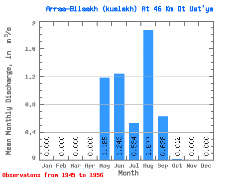
| Statistic | Jan | Feb | Mar | Apr | May | Jun | Jul | Aug | Sep | Oct | Nov | Dec | Annual |
|---|---|---|---|---|---|---|---|---|---|---|---|---|---|
| Mean | 0.00 | 0.00 | 0.00 | 0.00 | 1.19 | 1.24 | 0.53 | 1.88 | 0.63 | 0.01 | 0.00 | 0.00 | 0.46 |
| Standard Deviation | 0.00 | 0.00 | 0.00 | 0.00 | 1.30 | 1.15 | 0.42 | 3.18 | 0.69 | 0.02 | 0.00 | 0.00 | 0.41 |
| Min | 0.00 | 0.00 | 0.00 | 0.00 | 0.08 | 0.14 | 0.05 | 0.11 | 0.03 | 0.00 | 0.00 | 0.00 | 0.13 |
| Max | 0.00 | 0.00 | 0.00 | 0.00 | 4.23 | 3.44 | 1.23 | 9.80 | 1.72 | 0.05 | 0.00 | 0.00 | 1.32 |
| Coefficient of Variation | 1.10 | 0.93 | 0.78 | 1.69 | 1.10 | 1.41 | 0.90 |
 Return to R-Arctic Net Home Page