|
|
|||||||||||||||||
| Point ID: 7911 | Downloads | Plots | Site Data | Code: 3434 |
|
|
|||||||||||||||||
| Download | |
|---|---|
| Site Descriptor Information | Site Time Series Data |
| Link to all available data | |
| View: | Time Series | All |
| Units: | m3/s |
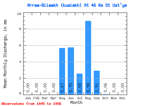
| Statistic | Jan | Feb | Mar | Apr | May | Jun | Jul | Aug | Sep | Oct | Nov | Dec | Annual |
|---|---|---|---|---|---|---|---|---|---|---|---|---|---|
| Mean | 0.00 | 0.00 | 0.00 | 0.00 | 5.67 | 5.75 | 2.56 | 8.97 | 2.91 | 0.06 | 0.00 | 0.00 | 25.73 |
| Standard Deviation | 0.00 | 0.00 | 0.00 | 0.00 | 6.21 | 5.34 | 2.00 | 15.19 | 3.21 | 0.08 | 0.00 | 0.00 | 23.16 |
| Min | 0.00 | 0.00 | 0.00 | 0.00 | 0.40 | 0.65 | 0.23 | 0.53 | 0.14 | 0.01 | 0.00 | 0.00 | 7.33 |
| Max | 0.00 | 0.00 | 0.00 | 0.00 | 20.23 | 15.92 | 5.88 | 46.87 | 7.96 | 0.26 | 0.00 | 0.00 | 74.50 |
| Coefficient of Variation | 1.10 | 0.93 | 0.78 | 1.69 | 1.10 | 1.41 | 0.90 |
 Return to R-Arctic Net Home Page