|
|
|||||||||||||||||
| Point ID: 7909 | Downloads | Plots | Site Data | Code: 3431 |
|
|
|||||||||||||||||
| Download | |
|---|---|
| Site Descriptor Information | Site Time Series Data |
| Link to all available data | |
| View: | Time Series | All |
| Units: | mm |
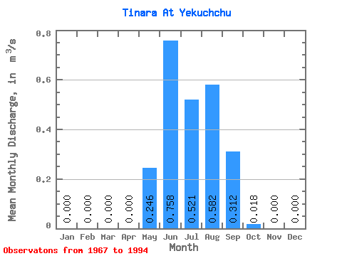
| Statistic | Jan | Feb | Mar | Apr | May | Jun | Jul | Aug | Sep | Oct | Nov | Dec | Annual |
|---|---|---|---|---|---|---|---|---|---|---|---|---|---|
| Mean | 0.00 | 0.00 | 0.00 | 0.00 | 0.25 | 0.76 | 0.52 | 0.58 | 0.31 | 0.02 | 0.00 | 0.00 | 0.18 |
| Standard Deviation | 0.00 | 0.00 | 0.00 | 0.00 | 0.26 | 0.92 | 0.46 | 0.45 | 0.26 | 0.03 | 0.00 | 0.00 | 0.12 |
| Min | 0.00 | 0.00 | 0.00 | 0.00 | 0.01 | 0.01 | 0.03 | 0.04 | 0.01 | 0.00 | 0.00 | 0.00 | 0.03 |
| Max | 0.00 | 0.00 | 0.00 | 0.00 | 1.27 | 3.48 | 1.54 | 1.66 | 0.86 | 0.11 | 0.00 | 0.00 | 0.40 |
| Coefficient of Variation | 1.07 | 1.22 | 0.88 | 0.78 | 0.84 | 1.57 | 0.65 |
 Return to R-Arctic Net Home Page