|
|
|||||||||||||||||
| Point ID: 7909 | Downloads | Plots | Site Data | Code: 3431 |
|
|
|||||||||||||||||
| Download | |
|---|---|
| Site Descriptor Information | Site Time Series Data |
| Link to all available data | |
| View: | Time Series | All |
| Units: | m3/s |
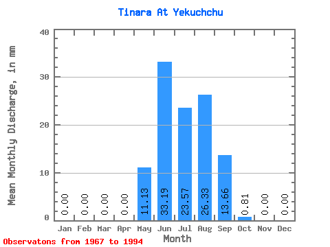
| Statistic | Jan | Feb | Mar | Apr | May | Jun | Jul | Aug | Sep | Oct | Nov | Dec | Annual |
|---|---|---|---|---|---|---|---|---|---|---|---|---|---|
| Mean | 0.00 | 0.00 | 0.00 | 0.00 | 11.13 | 33.19 | 23.58 | 26.34 | 13.66 | 0.84 | 0.00 | 0.00 | 94.64 |
| Standard Deviation | 0.00 | 0.00 | 0.00 | 0.00 | 11.94 | 40.41 | 20.67 | 20.53 | 11.50 | 1.31 | 0.00 | 0.00 | 61.48 |
| Min | 0.00 | 0.00 | 0.00 | 0.00 | 0.35 | 0.53 | 1.18 | 1.89 | 0.60 | 0.00 | 0.00 | 0.00 | 13.24 |
| Max | 0.00 | 0.00 | 0.00 | 0.00 | 57.45 | 152.40 | 69.66 | 75.10 | 37.65 | 4.98 | 0.00 | 0.00 | 211.11 |
| Coefficient of Variation | 1.07 | 1.22 | 0.88 | 0.78 | 0.84 | 1.57 | 0.65 |
 Return to R-Arctic Net Home Page