|
|
|||||||||||||||||
| Point ID: 7900 | Downloads | Plots | Site Data | Code: 3398 |
|
|
|||||||||||||||||
| Download | |
|---|---|
| Site Descriptor Information | Site Time Series Data |
| Link to all available data | |
| View: | Time Series | All |
| Units: | mm |
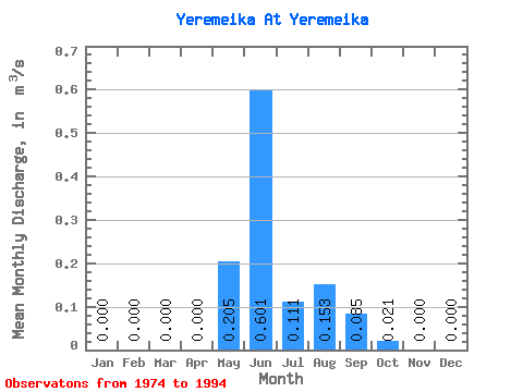
| Statistic | Jan | Feb | Mar | Apr | May | Jun | Jul | Aug | Sep | Oct | Nov | Dec | Annual |
|---|---|---|---|---|---|---|---|---|---|---|---|---|---|
| Mean | 0.00 | 0.00 | 0.00 | 0.00 | 0.20 | 0.60 | 0.11 | 0.15 | 0.09 | 0.02 | 0.00 | 0.00 | 0.07 |
| Standard Deviation | 0.00 | 0.00 | 0.00 | 0.00 | 0.30 | 0.31 | 0.08 | 0.16 | 0.08 | 0.04 | 0.00 | 0.00 | 0.02 |
| Min | 0.00 | 0.00 | 0.00 | 0.00 | 0.00 | 0.05 | 0.00 | 0.00 | 0.00 | 0.00 | 0.00 | 0.00 | 0.06 |
| Max | 0.00 | 0.00 | 0.00 | 0.00 | 0.97 | 1.18 | 0.22 | 0.50 | 0.24 | 0.13 | 0.00 | 0.00 | 0.11 |
| Coefficient of Variation | 1.48 | 0.52 | 0.72 | 1.07 | 0.92 | 1.96 | 0.25 |
 Return to R-Arctic Net Home Page