|
|
|||||||||||||||||
| Point ID: 7900 | Downloads | Plots | Site Data | Code: 3398 |
|
|
|||||||||||||||||
| Download | |
|---|---|
| Site Descriptor Information | Site Time Series Data |
| Link to all available data | |
| View: | Time Series | All |
| Units: | m3/s |
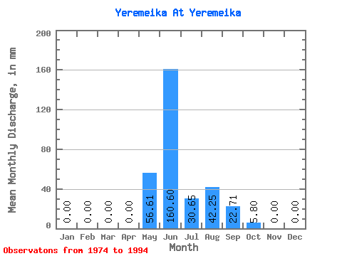
| Statistic | Jan | Feb | Mar | Apr | May | Jun | Jul | Aug | Sep | Oct | Nov | Dec | Annual |
|---|---|---|---|---|---|---|---|---|---|---|---|---|---|
| Mean | 0.00 | 0.00 | 0.00 | 0.00 | 56.67 | 160.54 | 30.57 | 42.28 | 22.83 | 5.75 | 0.00 | 0.00 | 241.95 |
| Standard Deviation | 0.00 | 0.00 | 0.00 | 0.00 | 84.14 | 82.85 | 21.92 | 45.07 | 21.07 | 11.30 | 0.00 | 0.00 | 59.43 |
| Min | 0.00 | 0.00 | 0.00 | 0.00 | 0.00 | 13.63 | 0.83 | 1.10 | 0.00 | 0.00 | 0.00 | 0.00 | 179.49 |
| Max | 0.00 | 0.00 | 0.00 | 0.00 | 267.80 | 315.31 | 60.74 | 138.04 | 64.13 | 35.89 | 0.00 | 0.00 | 346.24 |
| Coefficient of Variation | 1.48 | 0.52 | 0.72 | 1.07 | 0.92 | 1.96 | 0.25 |
 Return to R-Arctic Net Home Page