|
|
|||||||||||||||||
| Point ID: 7898 | Downloads | Plots | Site Data | Code: 3392 |
|
|
|||||||||||||||||
| Download | |
|---|---|
| Site Descriptor Information | Site Time Series Data |
| Link to all available data | |
| View: | Time Series | All |
| Units: | mm |
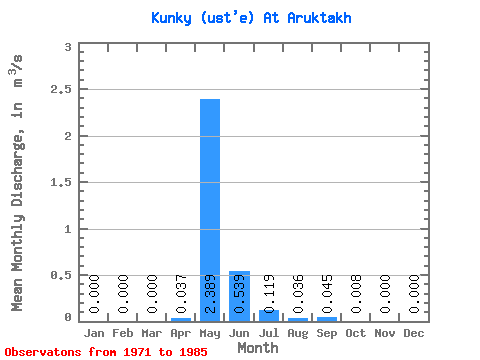
| Statistic | Jan | Feb | Mar | Apr | May | Jun | Jul | Aug | Sep | Oct | Nov | Dec | Annual |
|---|---|---|---|---|---|---|---|---|---|---|---|---|---|
| Mean | 0.00 | 0.00 | 0.00 | 0.04 | 2.39 | 0.54 | 0.12 | 0.04 | 0.04 | 0.01 | 0.00 | 0.00 | 0.25 |
| Standard Deviation | 0.00 | 0.00 | 0.00 | 0.06 | 1.11 | 0.47 | 0.12 | 0.07 | 0.10 | 0.03 | 0.00 | 0.00 | 0.10 |
| Min | 0.00 | 0.00 | 0.00 | 0.00 | 1.02 | 0.08 | 0.00 | 0.00 | 0.00 | 0.00 | 0.00 | 0.00 | 0.10 |
| Max | 0.00 | 0.00 | 0.00 | 0.20 | 4.56 | 1.89 | 0.31 | 0.21 | 0.31 | 0.11 | 0.00 | 0.00 | 0.44 |
| Coefficient of Variation | 1.66 | 0.47 | 0.88 | 1.00 | 1.99 | 2.21 | 3.51 | 0.40 |
 Return to R-Arctic Net Home Page