|
|
|||||||||||||||||
| Point ID: 7898 | Downloads | Plots | Site Data | Code: 3392 |
|
|
|||||||||||||||||
| Download | |
|---|---|
| Site Descriptor Information | Site Time Series Data |
| Link to all available data | |
| View: | Time Series | All |
| Units: | m3/s |
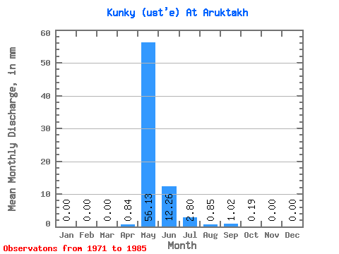
| Statistic | Jan | Feb | Mar | Apr | May | Jun | Jul | Aug | Sep | Oct | Nov | Dec | Annual |
|---|---|---|---|---|---|---|---|---|---|---|---|---|---|
| Mean | 0.00 | 0.00 | 0.00 | 0.85 | 56.13 | 12.25 | 2.80 | 0.84 | 1.02 | 0.20 | 0.00 | 0.00 | 69.49 |
| Standard Deviation | 0.00 | 0.00 | 0.00 | 1.41 | 26.19 | 10.74 | 2.81 | 1.67 | 2.26 | 0.69 | 0.00 | 0.00 | 27.55 |
| Min | 0.00 | 0.00 | 0.00 | 0.00 | 23.96 | 1.89 | 0.00 | 0.00 | 0.00 | 0.00 | 0.00 | 0.00 | 28.15 |
| Max | 0.00 | 0.00 | 0.00 | 4.55 | 107.12 | 42.97 | 7.28 | 4.93 | 7.05 | 2.58 | 0.00 | 0.00 | 120.84 |
| Coefficient of Variation | 1.66 | 0.47 | 0.88 | 1.00 | 1.99 | 2.21 | 3.51 | 0.40 |
 Return to R-Arctic Net Home Page