|
|
|||||||||||||||||
| Point ID: 789 | Downloads | Plots | Site Data | Code: 07JA003 |
|
|
|||||||||||||||||
| Download | |
|---|---|
| Site Descriptor Information | Site Time Series Data |
| Link to all available data | |
| View: | Time Series | All |
| Units: | mm |
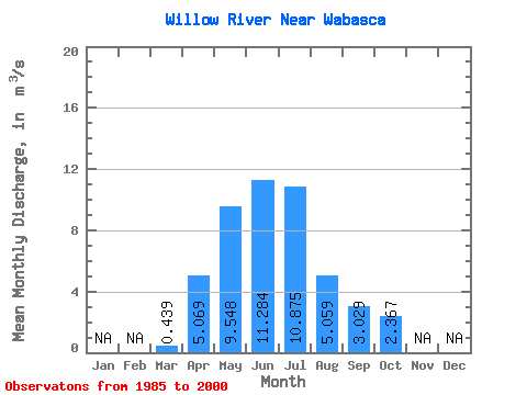
| Statistic | Jan | Feb | Mar | Apr | May | Jun | Jul | Aug | Sep | Oct | Nov | Dec | Annual |
|---|---|---|---|---|---|---|---|---|---|---|---|---|---|
| Mean | 0.44 | 5.07 | 9.55 | 11.28 | 10.88 | 5.06 | 3.03 | 2.37 | |||||
| Standard Deviation | 0.46 | 4.04 | 6.14 | 6.70 | 9.27 | 6.54 | 3.34 | 3.71 | |||||
| Min | 0.04 | 1.24 | 2.56 | 2.02 | 0.55 | 0.52 | 0.33 | 0.23 | |||||
| Max | 2.02 | 14.30 | 24.70 | 23.90 | 30.40 | 27.60 | 12.00 | 15.20 | |||||
| Coefficient of Variation | 1.04 | 0.80 | 0.64 | 0.59 | 0.85 | 1.29 | 1.10 | 1.57 |
 Return to R-Arctic Net Home Page