|
|
|||||||||||||||||
| Point ID: 789 | Downloads | Plots | Site Data | Code: 07JA003 |
|
|
|||||||||||||||||
| Download | |
|---|---|
| Site Descriptor Information | Site Time Series Data |
| Link to all available data | |
| View: | Time Series | All |
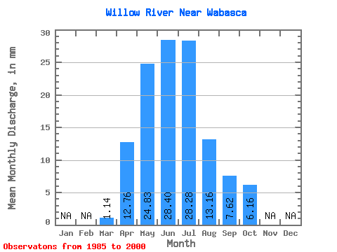
| Units: | m3/s |
| Statistic | Jan | Feb | Mar | Apr | May | Jun | Jul | Aug | Sep | Oct | Nov | Dec | Annual |
|---|---|---|---|---|---|---|---|---|---|---|---|---|---|
| Mean | 1.14 | 12.76 | 24.82 | 28.40 | 28.27 | 13.15 | 7.62 | 6.15 | |||||
| Standard Deviation | 1.18 | 10.17 | 15.97 | 16.85 | 24.10 | 16.99 | 8.41 | 9.64 | |||||
| Min | 0.09 | 3.12 | 6.66 | 5.08 | 1.42 | 1.35 | 0.83 | 0.61 | |||||
| Max | 5.25 | 35.99 | 64.22 | 60.14 | 79.04 | 71.76 | 30.20 | 39.52 | |||||
| Coefficient of Variation | 1.04 | 0.80 | 0.64 | 0.59 | 0.85 | 1.29 | 1.10 | 1.57 |
 Return to R-Arctic Net Home Page