|
|
|||||||||||||||||
| Point ID: 7886 | Downloads | Plots | Site Data | Code: 3368 |
|
|
|||||||||||||||||
| Download | |
|---|---|
| Site Descriptor Information | Site Time Series Data |
| Link to all available data | |
| View: | Time Series | All |
| Units: | mm |
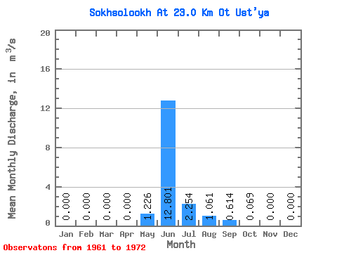
| Statistic | Jan | Feb | Mar | Apr | May | Jun | Jul | Aug | Sep | Oct | Nov | Dec | Annual |
|---|---|---|---|---|---|---|---|---|---|---|---|---|---|
| Mean | 0.00 | 0.00 | 0.00 | 0.00 | 1.23 | 12.80 | 2.25 | 1.06 | 0.61 | 0.07 | 0.00 | 0.00 | 1.50 |
| Standard Deviation | 0.00 | 0.00 | 0.00 | 0.00 | 1.94 | 4.56 | 1.27 | 1.73 | 0.54 | 0.08 | 0.00 | 0.00 | 0.42 |
| Min | 0.00 | 0.00 | 0.00 | 0.00 | 0.04 | 4.71 | 0.30 | 0.00 | 0.04 | 0.00 | 0.00 | 0.00 | 1.02 |
| Max | 0.00 | 0.00 | 0.00 | 0.00 | 5.44 | 18.40 | 3.13 | 4.27 | 1.37 | 0.22 | 0.00 | 0.00 | 1.94 |
| Coefficient of Variation | 1.58 | 0.36 | 0.56 | 1.63 | 0.87 | 1.18 | 0.28 |
 Return to R-Arctic Net Home Page