|
|
|||||||||||||||||
| Point ID: 7886 | Downloads | Plots | Site Data | Code: 3368 |
|
|
|||||||||||||||||
| Download | |
|---|---|
| Site Descriptor Information | Site Time Series Data |
| Link to all available data | |
| View: | Time Series | All |
| Units: | m3/s |
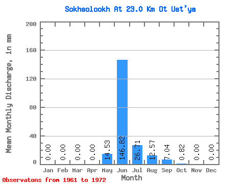
| Statistic | Jan | Feb | Mar | Apr | May | Jun | Jul | Aug | Sep | Oct | Nov | Dec | Annual |
|---|---|---|---|---|---|---|---|---|---|---|---|---|---|
| Mean | 0.00 | 0.00 | 0.00 | 0.00 | 14.52 | 146.82 | 26.71 | 12.58 | 7.05 | 0.82 | 0.00 | 0.00 | 209.77 |
| Standard Deviation | 0.00 | 0.00 | 0.00 | 0.00 | 22.94 | 52.30 | 15.08 | 20.45 | 6.14 | 0.96 | 0.00 | 0.00 | 58.55 |
| Min | 0.00 | 0.00 | 0.00 | 0.00 | 0.50 | 54.02 | 3.56 | 0.02 | 0.42 | 0.00 | 0.00 | 0.00 | 142.30 |
| Max | 0.00 | 0.00 | 0.00 | 0.00 | 64.46 | 211.03 | 37.09 | 50.60 | 15.71 | 2.61 | 0.00 | 0.00 | 270.80 |
| Coefficient of Variation | 1.58 | 0.36 | 0.56 | 1.63 | 0.87 | 1.18 | 0.28 |
 Return to R-Arctic Net Home Page