|
|
|||||||||||||||||
| Point ID: 7877 | Downloads | Plots | Site Data | Code: 3349 |
|
|
|||||||||||||||||
| Download | |
|---|---|
| Site Descriptor Information | Site Time Series Data |
| Link to all available data | |
| View: | Time Series | All |
| Units: | mm |
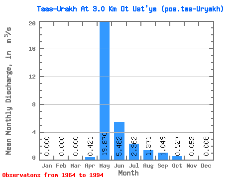
| Statistic | Jan | Feb | Mar | Apr | May | Jun | Jul | Aug | Sep | Oct | Nov | Dec | Annual |
|---|---|---|---|---|---|---|---|---|---|---|---|---|---|
| Mean | 0.00 | 0.00 | 0.00 | 0.42 | 19.87 | 5.48 | 2.36 | 1.37 | 1.05 | 0.53 | 0.05 | 0.01 | 2.45 |
| Standard Deviation | 0.00 | 0.00 | 0.00 | 0.83 | 10.75 | 3.75 | 3.10 | 3.85 | 1.27 | 0.74 | 0.09 | 0.03 | 1.25 |
| Min | 0.00 | 0.00 | 0.00 | 0.00 | 7.44 | 1.50 | 0.36 | 0.08 | 0.15 | 0.00 | 0.00 | 0.00 | 1.05 |
| Max | 0.00 | 0.00 | 0.00 | 2.78 | 45.00 | 17.00 | 13.10 | 21.10 | 5.94 | 3.64 | 0.39 | 0.16 | 5.92 |
| Coefficient of Variation | 1.96 | 0.54 | 0.68 | 1.31 | 2.81 | 1.21 | 1.40 | 1.75 | 4.08 | 0.51 |
 Return to R-Arctic Net Home Page