|
|
|||||||||||||||||
| Point ID: 7877 | Downloads | Plots | Site Data | Code: 3349 |
|
|
|||||||||||||||||
| Download | |
|---|---|
| Site Descriptor Information | Site Time Series Data |
| Link to all available data | |
| View: | Time Series | All |
| Units: | m3/s |
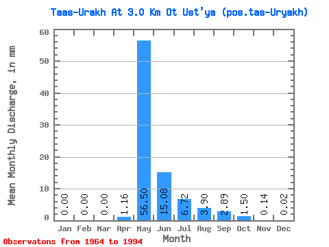
| Statistic | Jan | Feb | Mar | Apr | May | Jun | Jul | Aug | Sep | Oct | Nov | Dec | Annual |
|---|---|---|---|---|---|---|---|---|---|---|---|---|---|
| Mean | 0.00 | 0.00 | 0.00 | 1.16 | 56.49 | 15.08 | 6.71 | 3.90 | 2.89 | 1.50 | 0.14 | 0.02 | 82.08 |
| Standard Deviation | 0.00 | 0.00 | 0.00 | 2.27 | 30.55 | 10.32 | 8.82 | 10.95 | 3.48 | 2.09 | 0.25 | 0.09 | 41.85 |
| Min | 0.00 | 0.00 | 0.00 | 0.00 | 21.15 | 4.13 | 1.02 | 0.22 | 0.41 | 0.00 | 0.00 | 0.00 | 35.22 |
| Max | 0.00 | 0.00 | 0.00 | 7.65 | 127.93 | 46.78 | 37.24 | 59.98 | 16.34 | 10.35 | 1.07 | 0.46 | 198.20 |
| Coefficient of Variation | 1.96 | 0.54 | 0.68 | 1.31 | 2.81 | 1.21 | 1.40 | 1.75 | 4.08 | 0.51 |
 Return to R-Arctic Net Home Page