|
|
|||||||||||||||||
| Point ID: 7871 | Downloads | Plots | Site Data | Code: 3340 |
|
|
|||||||||||||||||
| Download | |
|---|---|
| Site Descriptor Information | Site Time Series Data |
| Link to all available data | |
| View: | Time Series | All |
| Units: | mm |
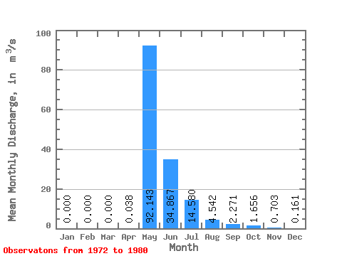
| Statistic | Jan | Feb | Mar | Apr | May | Jun | Jul | Aug | Sep | Oct | Nov | Dec | Annual |
|---|---|---|---|---|---|---|---|---|---|---|---|---|---|
| Mean | 0.00 | 0.00 | 0.00 | 0.04 | 92.14 | 34.87 | 14.58 | 4.54 | 2.27 | 1.66 | 0.70 | 0.16 | 12.73 |
| Standard Deviation | 0.00 | 0.00 | 0.00 | 0.10 | 26.15 | 19.64 | 19.43 | 10.20 | 1.20 | 0.85 | 0.51 | 0.12 | 4.08 |
| Min | 0.00 | 0.00 | 0.00 | 0.00 | 56.90 | 13.50 | 0.89 | 0.32 | 0.78 | 0.55 | 0.18 | 0.00 | 6.59 |
| Max | 0.00 | 0.00 | 0.00 | 0.28 | 126.00 | 72.30 | 61.00 | 31.70 | 4.67 | 2.93 | 1.62 | 0.35 | 18.75 |
| Coefficient of Variation | 2.55 | 0.28 | 0.56 | 1.33 | 2.25 | 0.53 | 0.51 | 0.72 | 0.75 | 0.32 |
 Return to R-Arctic Net Home Page