|
|
|||||||||||||||||
| Point ID: 7871 | Downloads | Plots | Site Data | Code: 3340 |
|
|
|||||||||||||||||
| Download | |
|---|---|
| Site Descriptor Information | Site Time Series Data |
| Link to all available data | |
| View: | Time Series | All |
| Units: | m3/s |
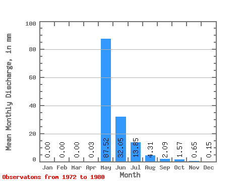
| Statistic | Jan | Feb | Mar | Apr | May | Jun | Jul | Aug | Sep | Oct | Nov | Dec | Annual |
|---|---|---|---|---|---|---|---|---|---|---|---|---|---|
| Mean | 0.00 | 0.00 | 0.00 | 0.04 | 87.50 | 32.05 | 13.85 | 4.31 | 2.09 | 1.57 | 0.65 | 0.15 | 142.45 |
| Standard Deviation | 0.00 | 0.00 | 0.00 | 0.09 | 24.84 | 18.05 | 18.45 | 9.69 | 1.10 | 0.81 | 0.47 | 0.12 | 45.62 |
| Min | 0.00 | 0.00 | 0.00 | 0.00 | 54.03 | 12.41 | 0.84 | 0.30 | 0.72 | 0.52 | 0.17 | 0.00 | 73.76 |
| Max | 0.00 | 0.00 | 0.00 | 0.26 | 119.66 | 66.45 | 57.93 | 30.10 | 4.29 | 2.78 | 1.49 | 0.33 | 209.79 |
| Coefficient of Variation | 2.55 | 0.28 | 0.56 | 1.33 | 2.25 | 0.53 | 0.51 | 0.72 | 0.75 | 0.32 |
 Return to R-Arctic Net Home Page