|
|
|||||||||||||||||
| Point ID: 7846 | Downloads | Plots | Site Data | Code: 3257 |
|
|
|||||||||||||||||
| Download | |
|---|---|
| Site Descriptor Information | Site Time Series Data |
| Link to all available data | |
| View: | Time Series | All |
| Units: | mm |
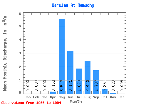
| Statistic | Jan | Feb | Mar | Apr | May | Jun | Jul | Aug | Sep | Oct | Nov | Dec | Annual |
|---|---|---|---|---|---|---|---|---|---|---|---|---|---|
| Mean | 0.00 | 0.00 | 0.00 | 0.16 | 5.54 | 3.17 | 1.87 | 2.44 | 1.74 | 0.36 | 0.03 | 0.01 | 1.33 |
| Standard Deviation | 0.00 | 0.00 | 0.00 | 0.35 | 2.07 | 2.19 | 1.23 | 2.58 | 1.04 | 0.38 | 0.05 | 0.01 | 0.34 |
| Min | 0.00 | 0.00 | 0.00 | 0.00 | 1.94 | 0.25 | 0.15 | 0.04 | 0.31 | 0.00 | 0.00 | 0.00 | 0.74 |
| Max | 0.00 | 0.00 | 0.00 | 1.11 | 9.76 | 10.00 | 4.60 | 12.80 | 4.62 | 1.39 | 0.16 | 0.06 | 2.09 |
| Coefficient of Variation | 2.15 | 0.37 | 0.69 | 0.66 | 1.06 | 0.60 | 1.05 | 1.82 | 2.87 | 0.26 |
 Return to R-Arctic Net Home Page