|
|
|||||||||||||||||
| Point ID: 7846 | Downloads | Plots | Site Data | Code: 3257 |
|
|
|||||||||||||||||
| Download | |
|---|---|
| Site Descriptor Information | Site Time Series Data |
| Link to all available data | |
| View: | Time Series | All |
| Units: | m3/s |
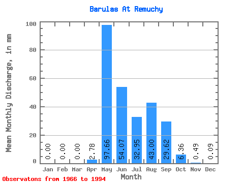
| Statistic | Jan | Feb | Mar | Apr | May | Jun | Jul | Aug | Sep | Oct | Nov | Dec | Annual |
|---|---|---|---|---|---|---|---|---|---|---|---|---|---|
| Mean | 0.00 | 0.00 | 0.00 | 2.79 | 97.64 | 54.07 | 32.94 | 42.99 | 29.62 | 6.37 | 0.50 | 0.08 | 276.23 |
| Standard Deviation | 0.00 | 0.00 | 0.00 | 6.00 | 36.43 | 37.40 | 21.74 | 45.48 | 17.76 | 6.67 | 0.91 | 0.23 | 71.62 |
| Min | 0.00 | 0.00 | 0.00 | 0.00 | 34.18 | 4.26 | 2.64 | 0.67 | 5.29 | 0.00 | 0.00 | 0.00 | 153.23 |
| Max | 0.00 | 0.00 | 0.00 | 18.93 | 171.96 | 170.53 | 81.05 | 225.52 | 78.78 | 24.49 | 2.73 | 1.00 | 434.42 |
| Coefficient of Variation | 2.15 | 0.37 | 0.69 | 0.66 | 1.06 | 0.60 | 1.05 | 1.82 | 2.87 | 0.26 |
 Return to R-Arctic Net Home Page