|
|
|||||||||||||||||
| Point ID: 7845 | Downloads | Plots | Site Data | Code: 3255 |
|
|
|||||||||||||||||
| Download | |
|---|---|
| Site Descriptor Information | Site Time Series Data |
| Link to all available data | |
| View: | Time Series | All |
| Units: | mm |
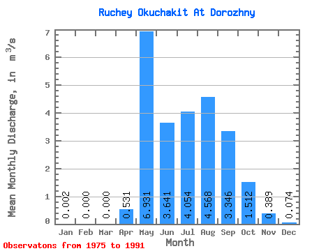
| Statistic | Jan | Feb | Mar | Apr | May | Jun | Jul | Aug | Sep | Oct | Nov | Dec | Annual |
|---|---|---|---|---|---|---|---|---|---|---|---|---|---|
| Mean | 0.00 | 0.00 | 0.00 | 0.53 | 6.93 | 3.64 | 4.05 | 4.57 | 3.35 | 1.51 | 0.39 | 0.07 | 2.30 |
| Standard Deviation | 0.01 | 0.00 | 0.00 | 0.71 | 3.03 | 1.92 | 2.06 | 2.74 | 1.73 | 0.65 | 0.25 | 0.10 | 0.79 |
| Min | 0.00 | 0.00 | 0.00 | 0.00 | 3.41 | 0.92 | 1.26 | 1.58 | 1.51 | 0.72 | 0.02 | 0.00 | 1.36 |
| Max | 0.02 | 0.00 | 0.00 | 2.22 | 15.30 | 6.99 | 8.76 | 11.50 | 7.32 | 3.38 | 1.02 | 0.29 | 3.95 |
| Coefficient of Variation | 2.99 | 1.34 | 0.44 | 0.53 | 0.51 | 0.60 | 0.52 | 0.43 | 0.65 | 1.28 | 0.34 |
 Return to R-Arctic Net Home Page