|
|
|||||||||||||||||
| Point ID: 7845 | Downloads | Plots | Site Data | Code: 3255 |
|
|
|||||||||||||||||
| Download | |
|---|---|
| Site Descriptor Information | Site Time Series Data |
| Link to all available data | |
| View: | Time Series | All |
| Units: | m3/s |
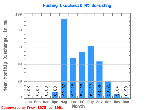
| Statistic | Jan | Feb | Mar | Apr | May | Jun | Jul | Aug | Sep | Oct | Nov | Dec | Annual |
|---|---|---|---|---|---|---|---|---|---|---|---|---|---|
| Mean | 0.03 | 0.00 | 0.00 | 6.88 | 92.81 | 47.18 | 54.28 | 61.16 | 43.36 | 20.25 | 5.04 | 0.99 | 362.34 |
| Standard Deviation | 0.07 | 0.00 | 0.00 | 9.22 | 40.51 | 24.94 | 27.64 | 36.71 | 22.40 | 8.63 | 3.29 | 1.27 | 124.35 |
| Min | 0.00 | 0.00 | 0.00 | 0.00 | 45.66 | 11.92 | 16.87 | 21.16 | 19.57 | 9.64 | 0.30 | 0.00 | 215.00 |
| Max | 0.25 | 0.00 | 0.00 | 28.77 | 204.88 | 90.59 | 117.30 | 153.99 | 94.87 | 45.26 | 13.22 | 3.88 | 622.63 |
| Coefficient of Variation | 2.99 | 1.34 | 0.44 | 0.53 | 0.51 | 0.60 | 0.52 | 0.43 | 0.65 | 1.28 | 0.34 |
 Return to R-Arctic Net Home Page