|
|
|||||||||||||||||
| Point ID: 783 | Downloads | Plots | Site Data | Code: 07HC001 |
|
|
|||||||||||||||||
| Download | |
|---|---|
| Site Descriptor Information | Site Time Series Data |
| Link to all available data | |
| View: | Time Series | All |
| Units: | mm |
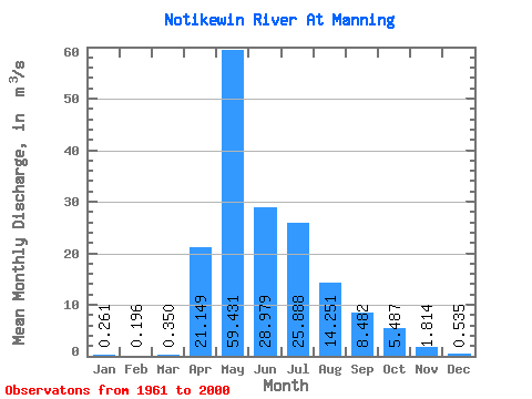
| Statistic | Jan | Feb | Mar | Apr | May | Jun | Jul | Aug | Sep | Oct | Nov | Dec | Annual |
|---|---|---|---|---|---|---|---|---|---|---|---|---|---|
| Mean | 0.26 | 0.20 | 0.35 | 21.15 | 59.43 | 28.98 | 25.89 | 14.25 | 8.48 | 5.49 | 1.81 | 0.54 | 13.90 |
| Standard Deviation | 0.27 | 0.22 | 0.70 | 17.79 | 38.63 | 23.94 | 21.44 | 16.14 | 9.13 | 6.03 | 1.63 | 0.47 | 6.65 |
| Min | 0.00 | 0.00 | 0.00 | 0.54 | 4.74 | 3.45 | 0.92 | 0.63 | 0.05 | 0.31 | 0.26 | 0.00 | 4.04 |
| Max | 1.12 | 1.00 | 4.43 | 71.60 | 149.00 | 111.00 | 94.00 | 74.10 | 41.10 | 32.50 | 8.38 | 2.57 | 33.40 |
| Coefficient of Variation | 1.04 | 1.12 | 2.01 | 0.84 | 0.65 | 0.83 | 0.83 | 1.13 | 1.08 | 1.10 | 0.90 | 0.88 | 0.48 |
 Return to R-Arctic Net Home Page