|
|
|||||||||||||||||
| Point ID: 783 | Downloads | Plots | Site Data | Code: 07HC001 |
|
|
|||||||||||||||||
| Download | |
|---|---|
| Site Descriptor Information | Site Time Series Data |
| Link to all available data | |
| View: | Time Series | All |
| Units: | m3/s |
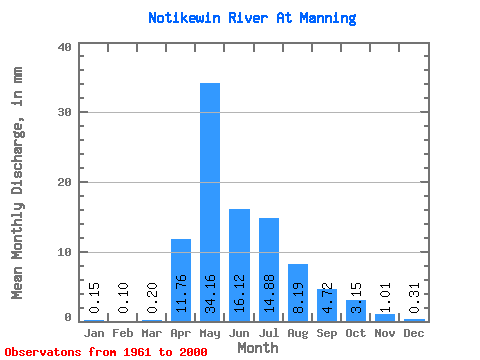
| Statistic | Jan | Feb | Mar | Apr | May | Jun | Jul | Aug | Sep | Oct | Nov | Dec | Annual |
|---|---|---|---|---|---|---|---|---|---|---|---|---|---|
| Mean | 0.15 | 0.10 | 0.20 | 11.71 | 34.01 | 16.05 | 14.81 | 8.15 | 4.70 | 3.14 | 1.00 | 0.31 | 93.75 |
| Standard Deviation | 0.15 | 0.11 | 0.40 | 9.85 | 22.11 | 13.26 | 12.27 | 9.24 | 5.06 | 3.45 | 0.91 | 0.27 | 44.86 |
| Min | 0.00 | 0.00 | 0.00 | 0.30 | 2.71 | 1.91 | 0.52 | 0.36 | 0.03 | 0.17 | 0.14 | 0.00 | 27.28 |
| Max | 0.64 | 0.52 | 2.54 | 39.66 | 85.26 | 61.48 | 53.79 | 42.40 | 22.76 | 18.60 | 4.64 | 1.47 | 225.22 |
| Coefficient of Variation | 1.04 | 1.12 | 2.01 | 0.84 | 0.65 | 0.83 | 0.83 | 1.13 | 1.08 | 1.10 | 0.90 | 0.88 | 0.48 |
 Return to R-Arctic Net Home Page