|
|
|||||||||||||||||
| Point ID: 7822 | Downloads | Plots | Site Data | Code: 3176 |
|
|
|||||||||||||||||
| Download | |
|---|---|
| Site Descriptor Information | Site Time Series Data |
| Link to all available data | |
| View: | Time Series | All |
| Units: | mm |
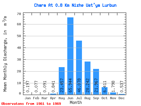
| Statistic | Jan | Feb | Mar | Apr | May | Jun | Jul | Aug | Sep | Oct | Nov | Dec | Annual |
|---|---|---|---|---|---|---|---|---|---|---|---|---|---|
| Mean | 0.20 | 0.08 | 0.09 | 0.84 | 23.46 | 65.94 | 46.08 | 28.24 | 21.97 | 6.41 | 1.80 | 0.54 | 16.30 |
| Standard Deviation | 0.15 | 0.11 | 0.15 | 1.00 | 11.22 | 24.49 | 17.20 | 13.69 | 7.46 | 1.58 | 0.86 | 0.26 | 2.92 |
| Min | 0.01 | 0.00 | 0.00 | 0.00 | 8.41 | 30.30 | 33.10 | 9.78 | 13.20 | 4.52 | 0.80 | 0.23 | 11.59 |
| Max | 0.42 | 0.33 | 0.43 | 3.41 | 42.90 | 98.40 | 87.70 | 48.30 | 36.20 | 9.38 | 3.52 | 1.05 | 21.63 |
| Coefficient of Variation | 0.76 | 1.39 | 1.67 | 1.19 | 0.48 | 0.37 | 0.37 | 0.48 | 0.34 | 0.25 | 0.48 | 0.48 | 0.18 |
 Return to R-Arctic Net Home Page