|
|
|||||||||||||||||
| Point ID: 7822 | Downloads | Plots | Site Data | Code: 3176 |
|
|
|||||||||||||||||
| Download | |
|---|---|
| Site Descriptor Information | Site Time Series Data |
| Link to all available data | |
| View: | Time Series | All |
| Units: | m3/s |
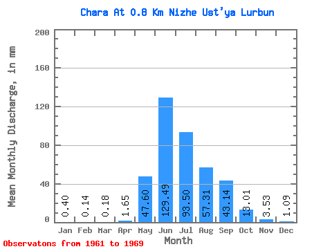
| Statistic | Jan | Feb | Mar | Apr | May | Jun | Jul | Aug | Sep | Oct | Nov | Dec | Annual |
|---|---|---|---|---|---|---|---|---|---|---|---|---|---|
| Mean | 0.40 | 0.14 | 0.18 | 1.65 | 47.59 | 129.49 | 93.48 | 57.30 | 43.13 | 13.01 | 3.53 | 1.09 | 389.80 |
| Standard Deviation | 0.30 | 0.20 | 0.31 | 1.97 | 22.75 | 48.09 | 34.90 | 27.77 | 14.64 | 3.20 | 1.68 | 0.53 | 69.91 |
| Min | 0.03 | 0.00 | 0.00 | 0.00 | 17.06 | 59.50 | 67.15 | 19.84 | 25.92 | 9.17 | 1.57 | 0.47 | 277.14 |
| Max | 0.85 | 0.61 | 0.87 | 6.70 | 87.03 | 193.22 | 177.93 | 97.99 | 71.08 | 19.03 | 6.91 | 2.13 | 517.21 |
| Coefficient of Variation | 0.76 | 1.39 | 1.67 | 1.19 | 0.48 | 0.37 | 0.37 | 0.48 | 0.34 | 0.25 | 0.48 | 0.48 | 0.18 |
 Return to R-Arctic Net Home Page