|
|
|||||||||||||||||
| Point ID: 7820 | Downloads | Plots | Site Data | Code: 3174 |
|
|
|||||||||||||||||
| Download | |
|---|---|
| Site Descriptor Information | Site Time Series Data |
| Link to all available data | |
| View: | Time Series | All |
| Units: | mm |
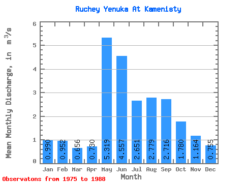
| Statistic | Jan | Feb | Mar | Apr | May | Jun | Jul | Aug | Sep | Oct | Nov | Dec | Annual |
|---|---|---|---|---|---|---|---|---|---|---|---|---|---|
| Mean | 0.99 | 0.95 | 0.66 | 0.73 | 5.32 | 4.56 | 2.65 | 2.78 | 2.72 | 1.78 | 1.16 | 0.76 | 1.97 |
| Standard Deviation | 1.61 | 1.61 | 0.30 | 0.25 | 2.61 | 2.66 | 1.18 | 1.41 | 1.10 | 0.68 | 0.52 | 0.24 | 0.53 |
| Min | 0.03 | 0.00 | 0.00 | 0.28 | 3.37 | 1.54 | 0.94 | 1.00 | 1.21 | 1.05 | 0.53 | 0.22 | 1.14 |
| Max | 6.00 | 6.20 | 1.04 | 1.10 | 12.80 | 9.95 | 4.72 | 6.16 | 5.57 | 3.52 | 2.15 | 1.16 | 2.63 |
| Coefficient of Variation | 1.62 | 1.69 | 0.46 | 0.34 | 0.49 | 0.58 | 0.45 | 0.51 | 0.41 | 0.38 | 0.45 | 0.31 | 0.27 |
 Return to R-Arctic Net Home Page