|
|
|||||||||||||||||
| Point ID: 7820 | Downloads | Plots | Site Data | Code: 3174 |
|
|
|||||||||||||||||
| Download | |
|---|---|
| Site Descriptor Information | Site Time Series Data |
| Link to all available data | |
| View: | Time Series | All |
| Units: | m3/s |
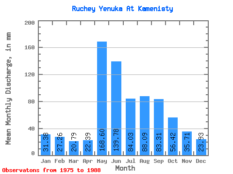
| Statistic | Jan | Feb | Mar | Apr | May | Jun | Jul | Aug | Sep | Oct | Nov | Dec | Annual |
|---|---|---|---|---|---|---|---|---|---|---|---|---|---|
| Mean | 31.39 | 27.49 | 20.80 | 22.39 | 168.58 | 139.78 | 84.01 | 88.08 | 83.32 | 56.41 | 35.69 | 23.91 | 735.13 |
| Standard Deviation | 50.96 | 46.41 | 9.56 | 7.63 | 82.69 | 81.69 | 37.46 | 44.75 | 33.73 | 21.67 | 16.02 | 7.50 | 197.95 |
| Min | 1.01 | 0.00 | 0.00 | 8.59 | 106.80 | 47.24 | 29.79 | 31.69 | 37.12 | 33.28 | 16.26 | 6.97 | 427.34 |
| Max | 190.15 | 179.03 | 32.96 | 33.74 | 405.66 | 305.21 | 149.59 | 195.22 | 170.86 | 111.56 | 65.95 | 36.76 | 980.73 |
| Coefficient of Variation | 1.62 | 1.69 | 0.46 | 0.34 | 0.49 | 0.58 | 0.45 | 0.51 | 0.41 | 0.38 | 0.45 | 0.31 | 0.27 |
 Return to R-Arctic Net Home Page