|
|
|||||||||||||||||
| Point ID: 781 | Downloads | Plots | Site Data | Code: 07HB001 |
|
|
|||||||||||||||||
| Download | |
|---|---|
| Site Descriptor Information | Site Time Series Data |
| Link to all available data | |
| View: | Time Series | All |
| Units: | mm |
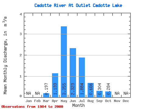
| Statistic | Jan | Feb | Mar | Apr | May | Jun | Jul | Aug | Sep | Oct | Nov | Dec | Annual |
|---|---|---|---|---|---|---|---|---|---|---|---|---|---|
| Mean | 0.20 | 1.13 | 3.35 | 2.32 | 1.88 | 0.69 | 0.30 | 0.28 | |||||
| Standard Deviation | 0.20 | 1.21 | 5.25 | 3.30 | 2.97 | 1.14 | 0.63 | 0.58 | |||||
| Min | 0.00 | 0.00 | 0.00 | 0.00 | 0.00 | 0.00 | 0.00 | 0.00 | |||||
| Max | 0.65 | 4.46 | 21.60 | 9.88 | 9.78 | 3.75 | 2.01 | 2.23 | |||||
| Coefficient of Variation | 0.99 | 1.06 | 1.56 | 1.42 | 1.58 | 1.66 | 2.08 | 2.04 |
 Return to R-Arctic Net Home Page