|
|
|||||||||||||||||
| Point ID: 781 | Downloads | Plots | Site Data | Code: 07HB001 |
|
|
|||||||||||||||||
| Download | |
|---|---|
| Site Descriptor Information | Site Time Series Data |
| Link to all available data | |
| View: | Time Series | All |
| Units: | m3/s |
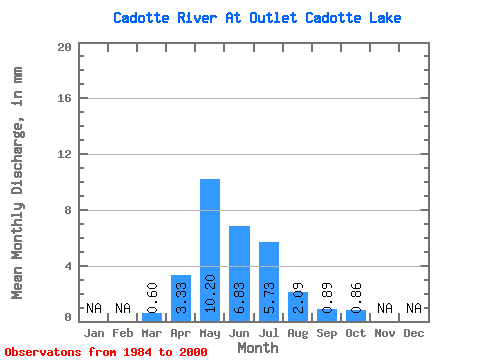
| Statistic | Jan | Feb | Mar | Apr | May | Jun | Jul | Aug | Sep | Oct | Nov | Dec | Annual |
|---|---|---|---|---|---|---|---|---|---|---|---|---|---|
| Mean | 0.60 | 3.33 | 10.20 | 6.83 | 5.73 | 2.09 | 0.90 | 0.86 | |||||
| Standard Deviation | 0.59 | 3.55 | 15.96 | 9.72 | 9.03 | 3.47 | 1.87 | 1.76 | |||||
| Min | 0.00 | 0.01 | 0.01 | 0.01 | 0.00 | 0.00 | 0.00 | 0.00 | |||||
| Max | 1.98 | 13.12 | 65.66 | 29.07 | 29.73 | 11.40 | 5.91 | 6.78 | |||||
| Coefficient of Variation | 0.99 | 1.06 | 1.56 | 1.42 | 1.58 | 1.66 | 2.08 | 2.04 |
 Return to R-Arctic Net Home Page