|
|
|||||||||||||||||
| Point ID: 7802 | Downloads | Plots | Site Data | Code: 3097 |
|
|
|||||||||||||||||
| Download | |
|---|---|
| Site Descriptor Information | Site Time Series Data |
| Link to all available data | |
| View: | Time Series | All |
| Units: | mm |
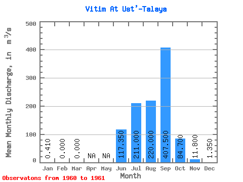
| Statistic | Jan | Feb | Mar | Apr | May | Jun | Jul | Aug | Sep | Oct | Nov | Dec | Annual |
|---|---|---|---|---|---|---|---|---|---|---|---|---|---|
| Mean | 0.41 | 0.00 | 0.00 | 117.35 | 211.00 | 220.00 | 407.50 | 84.70 | 11.80 | 1.35 | |||
| Standard Deviation | 51.83 | 80.61 | 111.72 | 296.28 | |||||||||
| Min | 0.41 | 0.00 | 0.00 | 80.70 | 154.00 | 141.00 | 198.00 | 84.70 | 11.80 | 1.35 | |||
| Max | 0.41 | 0.00 | 0.00 | 154.00 | 268.00 | 299.00 | 617.00 | 84.70 | 11.80 | 1.35 | |||
| Coefficient of Variation | 0.44 | 0.38 | 0.51 | 0.73 |
 Return to R-Arctic Net Home Page