|
|
|||||||||||||||||
| Point ID: 7802 | Downloads | Plots | Site Data | Code: 3097 |
|
|
|||||||||||||||||
| Download | |
|---|---|
| Site Descriptor Information | Site Time Series Data |
| Link to all available data | |
| View: | Time Series | All |
| Units: | m3/s |
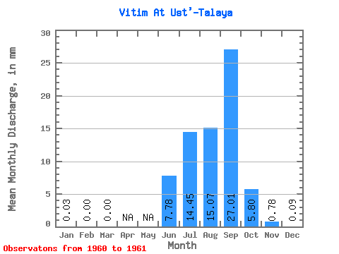
| Statistic | Jan | Feb | Mar | Apr | May | Jun | Jul | Aug | Sep | Oct | Nov | Dec | Annual |
|---|---|---|---|---|---|---|---|---|---|---|---|---|---|
| Mean | 0.03 | 0.00 | 0.00 | 7.78 | 14.45 | 15.07 | 27.01 | 5.80 | 0.78 | 0.09 | |||
| Standard Deviation | 3.44 | 5.52 | 7.65 | 19.64 | |||||||||
| Min | 0.03 | 0.00 | 0.00 | 5.35 | 10.55 | 9.66 | 13.13 | 5.80 | 0.78 | 0.09 | |||
| Max | 0.03 | 0.00 | 0.00 | 10.21 | 18.36 | 20.48 | 40.90 | 5.80 | 0.78 | 0.09 | |||
| Coefficient of Variation | 0.44 | 0.38 | 0.51 | 0.73 |
 Return to R-Arctic Net Home Page