|
|
|||||||||||||||||
| Point ID: 7749 | Downloads | Plots | Site Data | Code: 05AB041 |
|
|
|||||||||||||||||
| Download | |
|---|---|
| Site Descriptor Information | Site Time Series Data |
| Link to all available data | |
| View: | Time Series | All |
| Units: | mm |
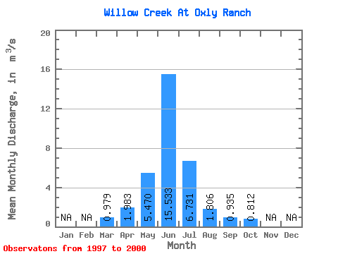
| Statistic | Jan | Feb | Mar | Apr | May | Jun | Jul | Aug | Sep | Oct | Nov | Dec | Annual |
|---|---|---|---|---|---|---|---|---|---|---|---|---|---|
| Mean | 0.98 | 1.98 | 5.47 | 15.53 | 6.73 | 1.81 | 0.94 | 0.81 | |||||
| Standard Deviation | 0.25 | 0.75 | 7.05 | 22.94 | 10.73 | 1.45 | 0.58 | 0.43 | |||||
| Min | 0.77 | 1.33 | 1.14 | 1.27 | 0.47 | 0.33 | 0.46 | 0.44 | |||||
| Max | 1.25 | 2.80 | 13.60 | 42.00 | 22.80 | 3.72 | 1.78 | 1.43 | |||||
| Coefficient of Variation | 0.25 | 0.38 | 1.29 | 1.48 | 1.59 | 0.80 | 0.62 | 0.53 |
 Return to R-Arctic Net Home Page