|
|
| Point ID: 7749 | Downloads | Plots | Site Data | Code: 05AB041 |
|
| Download | |
|---|---|
| Site Descriptor Information | Site Time Series Data |
| Link to all available data | |
|
|
|
| View: | Statistics | All |
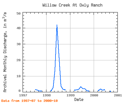
| Units: | mm |
| Year | Jan | Feb | Mar | Apr | May | Jun | Jul | Aug | Sep | Oct | Nov | Dec | Annual | 1997 | 1.53 | 1.15 | 0.68 | 0.68 | 1998 | 0.77 | 2.80 | 13.60 | 42.00 | 22.80 | 3.72 | 1.78 | 1.43 | 1999 | 1.25 | 1.33 | 1.67 | 3.33 | 2.12 | 2.02 | 0.82 | 0.70 | 2000 | 0.92 | 1.82 | 1.14 | 1.27 | 0.47 | 0.33 | 0.46 | 0.44 |
|---|
 Return to R-Arctic Net Home Page