|
|
|||||||||||||||||
| Point ID: 7731 | Downloads | Plots | Site Data | Code: Mo004 |
|
|
|||||||||||||||||
| Download | |
|---|---|
| Site Descriptor Information | Site Time Series Data |
| Link to all available data | |
| View: | Time Series | All |
| Units: | mm |
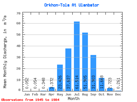
| Statistic | Jan | Feb | Mar | Apr | May | Jun | Jul | Aug | Sep | Oct | Nov | Dec | Annual |
|---|---|---|---|---|---|---|---|---|---|---|---|---|---|
| Mean | 0.05 | 0.05 | 0.35 | 3.37 | 23.43 | 37.64 | 61.51 | 51.91 | 31.90 | 11.67 | 2.72 | 0.26 | 14.67 |
| Standard Deviation | 0.06 | 0.07 | 0.98 | 3.15 | 21.71 | 23.91 | 33.18 | 37.10 | 19.27 | 5.44 | 1.78 | 0.15 | 5.93 |
| Min | 0.00 | 0.00 | 0.00 | 0.23 | 3.92 | 9.14 | 9.78 | 9.91 | 2.85 | 1.04 | 0.78 | 0.04 | 6.77 |
| Max | 0.17 | 0.17 | 3.60 | 10.50 | 95.00 | 111.00 | 118.00 | 151.00 | 75.00 | 21.00 | 8.60 | 0.52 | 23.39 |
| Coefficient of Variation | 1.11 | 1.27 | 2.82 | 0.93 | 0.93 | 0.64 | 0.54 | 0.71 | 0.60 | 0.47 | 0.66 | 0.58 | 0.40 |
 Return to R-Arctic Net Home Page