|
|
|||||||||||||||||
| Point ID: 7731 | Downloads | Plots | Site Data | Code: Mo004 |
|
|
|||||||||||||||||
| Download | |
|---|---|
| Site Descriptor Information | Site Time Series Data |
| Link to all available data | |
| View: | Time Series | All |
| Units: | m3/s |
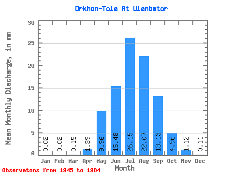
| Statistic | Jan | Feb | Mar | Apr | May | Jun | Jul | Aug | Sep | Oct | Nov | Dec | Annual |
|---|---|---|---|---|---|---|---|---|---|---|---|---|---|
| Mean | 0.02 | 0.02 | 0.15 | 1.39 | 9.96 | 15.48 | 26.15 | 22.06 | 13.13 | 4.96 | 1.12 | 0.11 | 73.50 |
| Standard Deviation | 0.03 | 0.03 | 0.42 | 1.29 | 9.23 | 9.84 | 14.10 | 15.77 | 7.93 | 2.31 | 0.73 | 0.07 | 29.72 |
| Min | 0.00 | 0.00 | 0.00 | 0.10 | 1.67 | 3.76 | 4.16 | 4.21 | 1.17 | 0.44 | 0.32 | 0.02 | 33.93 |
| Max | 0.07 | 0.07 | 1.53 | 4.32 | 40.38 | 45.67 | 50.16 | 64.19 | 30.86 | 8.93 | 3.54 | 0.22 | 117.16 |
| Coefficient of Variation | 1.11 | 1.27 | 2.82 | 0.93 | 0.93 | 0.64 | 0.54 | 0.71 | 0.60 | 0.47 | 0.66 | 0.58 | 0.40 |
 Return to R-Arctic Net Home Page