|
|
|||||||||||||||||
| Point ID: 7729 | Downloads | Plots | Site Data | Code: NO017 |
|
|
|||||||||||||||||
| Download | |
|---|---|
| Site Descriptor Information | Site Time Series Data |
| Link to all available data | |
| View: | Time Series | All |
| Units: | mm |
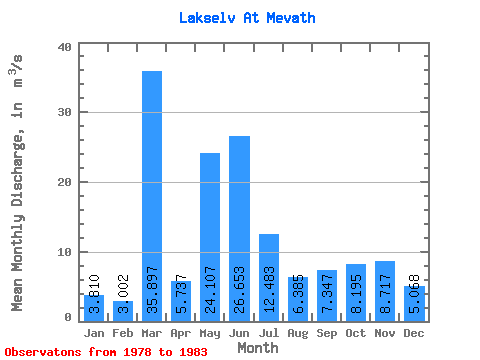
| Statistic | Jan | Feb | Mar | Apr | May | Jun | Jul | Aug | Sep | Oct | Nov | Dec | Annual |
|---|---|---|---|---|---|---|---|---|---|---|---|---|---|
| Mean | 3.81 | 3.00 | 35.90 | 5.74 | 24.11 | 26.65 | 12.48 | 6.38 | 7.35 | 8.20 | 8.72 | 5.07 | 13.28 |
| Standard Deviation | 2.78 | 1.69 | 80.91 | 2.17 | 5.58 | 6.18 | 9.10 | 6.14 | 4.43 | 3.71 | 8.42 | 2.42 | 8.39 |
| Min | 1.13 | 0.83 | 0.65 | 3.33 | 17.78 | 19.58 | 3.40 | 0.99 | 2.13 | 3.07 | 1.73 | 1.97 | 9.03 |
| Max | 8.48 | 5.22 | 201.00 | 8.91 | 30.91 | 34.45 | 25.68 | 16.78 | 13.55 | 12.28 | 24.79 | 8.86 | 28.25 |
| Coefficient of Variation | 0.73 | 0.56 | 2.25 | 0.38 | 0.23 | 0.23 | 0.73 | 0.96 | 0.60 | 0.45 | 0.97 | 0.48 | 0.63 |
 Return to R-Arctic Net Home Page