|
|
|||||||||||||||||
| Point ID: 7729 | Downloads | Plots | Site Data | Code: NO017 |
|
|
|||||||||||||||||
| Download | |
|---|---|
| Site Descriptor Information | Site Time Series Data |
| Link to all available data | |
| View: | Time Series | All |
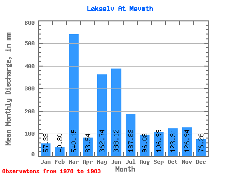
| Units: | m3/s |
| Statistic | Jan | Feb | Mar | Apr | May | Jun | Jul | Aug | Sep | Oct | Nov | Dec | Annual |
|---|---|---|---|---|---|---|---|---|---|---|---|---|---|
| Mean | 57.32 | 41.15 | 540.07 | 83.54 | 362.68 | 388.12 | 187.81 | 96.06 | 106.98 | 123.29 | 126.93 | 76.25 | 2353.79 |
| Standard Deviation | 41.79 | 23.11 | 1217.31 | 31.58 | 84.02 | 90.05 | 136.84 | 92.45 | 64.51 | 55.84 | 122.61 | 36.34 | 1487.01 |
| Min | 17.00 | 11.38 | 9.79 | 48.49 | 267.50 | 285.12 | 51.15 | 14.86 | 31.02 | 46.19 | 25.19 | 29.64 | 1601.64 |
| Max | 127.58 | 71.56 | 3024.03 | 129.75 | 465.04 | 501.65 | 386.35 | 252.45 | 197.31 | 184.75 | 360.99 | 133.30 | 5009.56 |
| Coefficient of Variation | 0.73 | 0.56 | 2.25 | 0.38 | 0.23 | 0.23 | 0.73 | 0.96 | 0.60 | 0.45 | 0.97 | 0.48 | 0.63 |
 Return to R-Arctic Net Home Page