|
|
|||||||||||||||||
| Point ID: 7719 | Downloads | Plots | Site Data | Code: II003 |
|
|
|||||||||||||||||
| Download | |
|---|---|
| Site Descriptor Information | Site Time Series Data |
| Link to all available data | |
| View: | Time Series | All |
| Units: | mm |
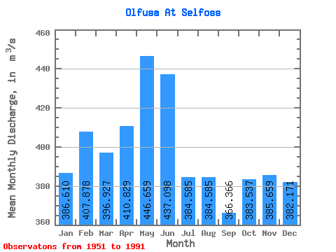
| Statistic | Jan | Feb | Mar | Apr | May | Jun | Jul | Aug | Sep | Oct | Nov | Dec | Annual |
|---|---|---|---|---|---|---|---|---|---|---|---|---|---|
| Mean | 386.61 | 407.88 | 396.93 | 410.83 | 446.66 | 437.10 | 384.58 | 384.58 | 366.37 | 383.54 | 385.66 | 382.17 | 397.74 |
| Standard Deviation | 94.10 | 105.67 | 127.62 | 108.51 | 91.94 | 72.80 | 59.16 | 95.87 | 76.62 | 84.47 | 107.56 | 95.09 | 47.52 |
| Min | 262.00 | 279.00 | 270.00 | 245.00 | 282.00 | 308.00 | 306.00 | 285.00 | 244.00 | 251.00 | 256.00 | 248.00 | 319.00 |
| Max | 599.00 | 742.00 | 989.00 | 814.00 | 720.00 | 642.00 | 603.00 | 777.00 | 605.00 | 589.00 | 749.00 | 774.00 | 507.67 |
| Coefficient of Variation | 0.24 | 0.26 | 0.32 | 0.26 | 0.21 | 0.17 | 0.15 | 0.25 | 0.21 | 0.22 | 0.28 | 0.25 | 0.12 |
 Return to R-Arctic Net Home Page