|
|
|||||||||||||||||
| Point ID: 7719 | Downloads | Plots | Site Data | Code: II003 |
|
|
|||||||||||||||||
| Download | |
|---|---|
| Site Descriptor Information | Site Time Series Data |
| Link to all available data | |
| View: | Time Series | All |
| Units: | m3/s |
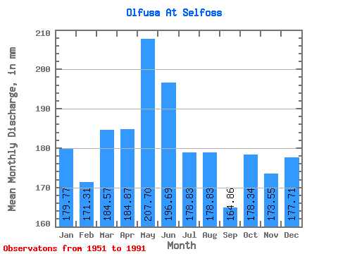
| Statistic | Jan | Feb | Mar | Apr | May | Jun | Jul | Aug | Sep | Oct | Nov | Dec | Annual |
|---|---|---|---|---|---|---|---|---|---|---|---|---|---|
| Mean | 179.75 | 172.78 | 184.54 | 184.87 | 207.66 | 196.69 | 178.81 | 178.81 | 164.87 | 178.32 | 173.55 | 177.68 | 2179.29 |
| Standard Deviation | 43.75 | 44.76 | 59.34 | 48.83 | 42.75 | 32.76 | 27.51 | 44.57 | 34.48 | 39.27 | 48.40 | 44.21 | 260.35 |
| Min | 121.81 | 118.19 | 125.53 | 110.25 | 131.11 | 138.60 | 142.27 | 132.50 | 109.80 | 116.70 | 115.20 | 115.30 | 1747.85 |
| Max | 278.49 | 314.32 | 459.82 | 366.30 | 334.75 | 288.90 | 280.35 | 361.25 | 272.25 | 273.84 | 337.05 | 359.86 | 2781.59 |
| Coefficient of Variation | 0.24 | 0.26 | 0.32 | 0.26 | 0.21 | 0.17 | 0.15 | 0.25 | 0.21 | 0.22 | 0.28 | 0.25 | 0.12 |
 Return to R-Arctic Net Home Page