|
|
|||||||||||||||||
| Point ID: 7705 | Downloads | Plots | Site Data | Code: 15564800 |
|
|
|||||||||||||||||
| Download | |
|---|---|
| Site Descriptor Information | Site Time Series Data |
| Link to all available data | |
| View: | Time Series | All |
| Units: | mm |
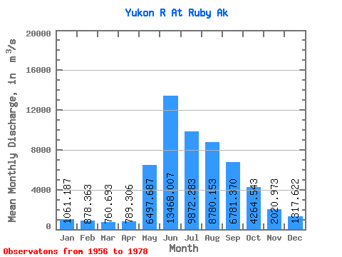
| Statistic | Jan | Feb | Mar | Apr | May | Jun | Jul | Aug | Sep | Oct | Nov | Dec | Annual |
|---|---|---|---|---|---|---|---|---|---|---|---|---|---|
| Mean | 1061.19 | 878.36 | 760.69 | 789.31 | 6497.69 | 13468.01 | 9872.28 | 8780.15 | 6781.37 | 4264.54 | 2020.97 | 1317.62 | 4756.50 |
| Standard Deviation | 152.09 | 124.93 | 128.36 | 110.26 | 2241.99 | 4110.82 | 2091.73 | 1871.71 | 1444.43 | 794.02 | 411.36 | 278.40 | 778.10 |
| Min | 821.19 | 651.29 | 481.39 | 523.86 | 2964.77 | 8044.82 | 7033.90 | 6388.28 | 4782.72 | 2557.58 | 1330.89 | 932.76 | 3551.43 |
| Max | 1415.84 | 1136.64 | 990.24 | 962.77 | 11035.08 | 24496.90 | 15531.79 | 13376.88 | 10477.23 | 5652.04 | 2775.05 | 1875.42 | 6485.03 |
| Coefficient of Variation | 0.14 | 0.14 | 0.17 | 0.14 | 0.34 | 0.30 | 0.21 | 0.21 | 0.21 | 0.19 | 0.20 | 0.21 | 0.16 |
 Return to R-Arctic Net Home Page