|
|
|||||||||||||||||
| Point ID: 7705 | Downloads | Plots | Site Data | Code: 15564800 |
|
|
|||||||||||||||||
| Download | |
|---|---|
| Site Descriptor Information | Site Time Series Data |
| Link to all available data | |
| View: | Time Series | All |
| Units: | m3/s |
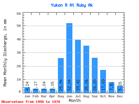
| Statistic | Jan | Feb | Mar | Apr | May | Jun | Jul | Aug | Sep | Oct | Nov | Dec | Annual |
|---|---|---|---|---|---|---|---|---|---|---|---|---|---|
| Mean | 4.24 | 3.19 | 3.04 | 3.05 | 25.94 | 52.04 | 39.41 | 35.05 | 26.20 | 17.02 | 7.81 | 5.26 | 223.78 |
| Standard Deviation | 0.61 | 0.45 | 0.51 | 0.43 | 8.95 | 15.88 | 8.35 | 7.47 | 5.58 | 3.17 | 1.59 | 1.11 | 36.61 |
| Min | 3.28 | 2.37 | 1.92 | 2.02 | 11.84 | 31.09 | 28.08 | 25.50 | 18.48 | 10.21 | 5.14 | 3.72 | 167.09 |
| Max | 5.65 | 4.13 | 3.95 | 3.72 | 44.05 | 94.66 | 62.01 | 53.40 | 40.48 | 22.56 | 10.72 | 7.49 | 305.11 |
| Coefficient of Variation | 0.14 | 0.14 | 0.17 | 0.14 | 0.34 | 0.30 | 0.21 | 0.21 | 0.21 | 0.19 | 0.20 | 0.21 | 0.16 |
 Return to R-Arctic Net Home Page